


CHARLESTON, W.Va. – A week of wintry weather continues in West Virginia this weekend with projections calling for snowfall in most of West Virginia and heavy accumulations in northern parts of the state.
The National Weather Service expects the most significant snowfall to start rolling through Saturday afternoon.
“From late Saturday afternoon through Sunday, we’re thinking anywhere from potentially 1-3 inches across the southern part of the state and then anywhere from 4-6 inches across the northern part of the state,” NWS meteorologist Joe Curtis told MetroNews.
That snow is expected to carry on falling early on Sunday. A Winter Storm Warning is in effect for a significant number of counties in the northern portion of the state with areas more to the south under a Winter Weather Advisory.
“We’re going to see the snow mostly confined to central and northern West Virginia. By Sunday morning, we’ll still see some snow showers but it’ll be wrapping up by the middle of the day Sunday,” Curtis said.
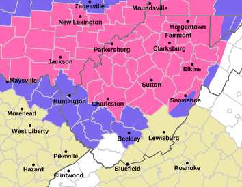
That snow will be paired with cold temperatures around the state, meaning that roadways will become covered as it falls. Driving conditions are likely to deteriorate as Saturday night goes on.
“Temperatures are also going to be turning much colder Saturday night and into Sunday so once that snow starts falling Saturday afternoon, that’s going to start sticking on the roadways,” Curtis said.
As the snowfall begins to let up on Sunday, the cold conditions are likely to keep the accumulated snow from melting. That means to travel with care even after it stops falling.
“We’re going to have snow accumulating on the roadways, and that’s going to make things really slick, even into much of Sunday, because Sunday, temperatures are not going to really budge much above 20 degrees even across the lowlands,” Curtis said.