


CHARLESTON, W.Va. — Gov. Patrick Morrisey has all 55 counties under a state of emergency with a powerful winter storm expected to enter the Mountain State late Saturday afternoon.

Morrisey has also asked for an emergency disaster declaration from President Donald Trump before the storm arrives.
A news release from Morrisey’s office said, “After consultation with FEMA and Federal Homeland Security, it was determined that a Presidential Emergency Declaration was appropriate because it would allow federal authorities to stage assets in advance of the storm. It would also allow the federal government to deliver assistance at an accelerated rate should the conditions dictate.”
National Weather Service Meteorologist Megan Kiebler said snow totals will be held down in the southern counties because of ice.
“There’s a warm wedge of temperatures moving from southwestern Virginia into the West Virginia foothills. That’s going move in overnight tonight (Saturday) into Sunday and what that’s actually going to do is to cause that changeover in precipitation overnight into a more wintry mix and freezing rain and that’s going to bring those totals that we’re concerned about,” Kiebler told MetroNews Saturday morning.
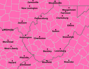
BEFORE THE STORM: Precipitation, falling as snow, will first arrive to the southwestern portions of the area later this morning and spread northward as the day progresses. Winter Storm Warnings will go into effect and remain in place through Monday morning. pic.twitter.com/izQ0k9nuHL
— NWS Charleston, WV (@NWSCharlestonWV) January 24, 2026
The combination of snow transitioning to ice leads to travel concerns and the possibility of substantial power outages, Kiebler said.

“The higher amounts of ice (expected) more toward the Beckley area and up into the higher terrain,” Kiebler said “That could be anywhere from a quarter to a half-an-inch in spots depending on where those warmer temperatures set up overnight.
Kiebler said northwest West Virginia, the northern and eastern panhandles will get the most snow because the transition, if it comes, will come later in the day on Sunday. Some areas could get 10 inches or more of snow. The areas where it turns to ice earlier could pick up 4 to 8 inches.
Mon Power spokesman Will Boye said the utility is preparing for possible outages.
“Just a few inches of wet heavy snow or ice can cling to equipment and vegetation,” Boye said. “It really increases the risk of broken branches and downed lines.”
To prepare, Boye said to have a supply of nonperishable food, a can opener, and a portable radio with extra batteries. Remember that temporary generators cannot be operated in a home or garage; they must be kept outside with plenty of ventilation.
“Make sure your electronic devices are fully charged—cell phones, laptops, or tablets,” Boye said. “You’ll also want a car charger ready to charge your devices if your power is out.”
Appalachian Power Company spokesperson Ashley Workman said the company has contracted with extra crews if needed.
“That’s great news for us because more boots on the ground ultimately means we are able to work faster and people are able to get the lights back on quicker,” Workman said.
Kiebler said the frigid air will return to the state at around sunset Sunday for more snow.
“That one final push late Sunday night into Monday morning before things wrap-up along the mountains,” she said.