


CHARLESTON, W.Va. — The National Weather Service has four separate advisories, watches and warnings posted for the Mountain State heading into the weekend.
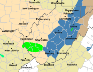
Heavy rain Thursday night and early Friday morning has Boone, Lincoln, Logan, Mingo, Raleigh and Wayne counties under a flood warning until late Friday afternoon.
Meteorologists have posted a wind advisory for the Potomac Highlands until 10 p.m. Friday with wind gusts up to 50 mph expected.
The majority of the rest of the state is under a special weather statement through Friday for windy conditions.
“Strong winds are moving through the area behind the passage of a cold front. Southwest winds of 15 to 25 mph with gusts up to 50 mph may continue for the rest of the afternoon before diminishing
toward evening,” the NWS said.
The weather service has posted a winter storm watch for Clay, Braxton, Lewis, Taylor, Upshur, Barbour, Raleigh, Fayette, Nicholas, Webster, Pocahontas and Randolph counties for late Saturday night through Monday evening with lake effect snow expected.
“Total snow accumulation between 5 and 12 inches possible. Winds could gust as high as 40 mph,” the weather service said.