


GLENVILLE, W.Va. — The National Weather Service has a severe thunderstorm watch in effect for most of West Virginia until 9 p.m. Wednesday as strong thunderstorms move through the state.
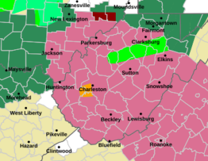
The watch covers the entire state from Fairmont south.
The Weather Service is issuing severe thunderstorm warnings when the storms pop up. There was a severe thunderstorm warning for Kanawha County.
A flood warning remained in effect for parts of Roane, Braxton, Calhoun, Gilmer, Barbour, Randolph, Upshur, Harrison, Lewis, and Taylor counties into mid-afternoon Wednesday.
By noon most of the counties reported some streams were running near capacity, but only had flooding in low lying areas where nuisance flooding is common in a downpour.
The highest water was in Gilmer and Lewis counties.
Gilmer County Emergency Services Director Eric Squires said a handful of homes were surrounded by water, but only one was reported to have actual water inside the structure. Several roads, including Route 33 were closed by flooded creeks. In Lewis County, there were no reports of any homes impacted, but several county roads were closed temporarily while waiting for the water to go down.
Barbour County Emergency Manager Corey Brandon said there were several roads across his county covered in water, but the rain had stopped and they were starting to drain down. Schools dismissed early in hopes of getting children home before the next storm hit. Brandon said they weather service expected close to an inch of rain in the next six hours which could complicate things.
The National Weather Service has a flood watch posted for more than 30 West Virginia counties through late Wednesday night. Starting Thursday, a cold front is expected to arrive which ill push rain out of West Virginia and give way to an extended dry spell.