


CHARLESTON, W.Va. — A tropical air mass will continue to impact weather in West Virginia through the end of the work week.
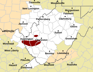
A line of storms fueled by that muggy air hit parts of Kanawha, Lincoln, Boone and Wayne counties hard during morning rush hour Wednesday.
The National Weather Service issued a flash flood warning for sections of those counties into early Wednesday afternoon.
“It was coming down at such a heavy rate that the drainage was taking a little bit to catch up and that especially combined with the morning commute can create issues on the roadways,” according National Weather Service Meteorologist Joe Curtis.
The conditions are forecasted to continue Thursday and Friday with flooding a possibility throughout the state, Curtis said.
“We’ll have chances for rain both days and both of those days could feature heavy downpours,” he said. “So if we get some situations where we get some heavy downpours, especially multiple storms that move over these same areas, we could be looking at more flooding problems.”
Curtis said there are lots of disturbances moving through the atmosphere triggering the showers and thunderstorms.
“That combined with humidity is creating these tropical-like downpours for us,” Curtis said.
The window to watch for the next chance for heavy storms is late-afternoon Thursday and afternoon and evening hours on Friday.