


ST. MARYS, W.Va. — A severe summer storm bearing the hallmarks of a tornado tore through Pleasants County late Tuesday afternoon, leaving a distinct path of destruction that crossed the Ohio River and damaged local infrastructure.
According to firsthand accounts and images provided by local witness C.R. Neale, the violent storm system produced significant damage to mature trees and a major bridge structure as it moved through the Mid-Ohio Valley. While the National Weather Service has not yet officially confirmed whether the damage was caused by a tornado or a severe microburst, the localized intensity of the destruction points to extreme wind speeds.
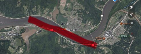
Based on witness observations and a mapped trajectory of the aftermath, the path of major damage was highly localized but severe. The destruction began in Belmont, West Virginia, before the storm track pushed across the Ohio River into Newport, Ohio, and then carved its way back up the hill toward St. Marys, West Virginia.
Infrastructure and Environmental Impact
-
Bridge Damage: Multiple photos from the scene show critical damage to the truss bridge connecting St. Marys and Newport. A large green highway sign and its heavy metal scaffolding were completely bent backward and ripped from their securements, left dangling precariously off the side of the bridge over the riverbank below.
-
Widespread Tree Damage: The heavy winds snapped the trunks of mature trees like matchsticks along the forested hillsides between Belmont and St. Marys.
-
Riverbank Destruction: Dense clusters of trees were entirely uprooted and stripped of their branches directly along the banks of the Ohio River.
As local emergency management and road crews begin cleanup efforts, residents are being warned to remain vigilant regarding flood threats. In addition to the wind damage, heavy torrential rains associated with Tuesday’s severe squall lines are expected to cause rapid rises in local waterways. Forecasters and local observers anticipate that regional rivers—including the Little Kanawha and eventually the Monongahela—will swell dramatically in the coming days as runoff moves through the watersheds.
(Stay with WVMetroNews.com for further updates on this developing weather story as official NWS damage assessments are released.)