


CHARLESTON, W.Va. — Lines of storms will continue to move across West Virginia into Tuesday evening.
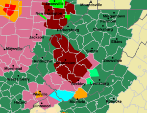
The storms out of the west and northwest are packing a pretty powerful punch.
By 9 o’clock Tuesday night, Appalachian Power reported around 20.500 of its customers in West Virginia were without power. ApCo said the most-affected areas in the state were Charleston, Hico, and Hamlin. ApCo estimated that service would be restored by 11 p.m. Wednesday night.
The National Weather Service has issued a number of flash flood warnings and in some cases extended those warnings including a flood warning for parts of Kanawha, Roane, Jackson, Mason and Putnam counties until 6:15 p.m. Tuesday.
The weather service has most all the state under a severe thunderstorm watch through the rest of Tuesday.
The storms have been fairly quick-moving.
There’s going to be a chance for the storms to continue for the next few days and conditions prevail.
The Nitro Fire Department performed some water rescues in the Heizer Creek area of Putnam County.
Kanawha County Homeland Security and Emergency Management Director C.W. Sigman said anyone living in a flood-prone area should remain alert.
“You may want to think about where you’re going to go when the water starts getting up and getting out of the house before the water starts getting in,” Sigman said.

Point Pleasant Mayor Amber Tatterson said it was raining sideways in Point Pleasant Tuesday.
“We actually had water coming in around our windows into our lobby,” Tatterson said on MetroNews Midday. “We’re out there with brooms trying to sweep it outside and then getting our mops. We had water going everywhere.”
Tatterson said there was street flooding.
“When you have downpours like that obviously the systems can’t handle it,” she said.