


CHARLESTON, W.Va. — Damage assessment will especially be the focus in the southern half of the state Sunday after Saturday’s heavy rains produced significant levels of flooding to the region.
National Weather Service Meteorologist in Charleston John Peck gave an update Sunday on what the heavy rainfall brought with it Saturday night into Sunday morning.
He said an average of 1.5 to 2.5 inches or rain fell over most the state, but across the Southern Coalfields, especially into Southwest Virginia, the rainfall was substantially worse, approaching 3 to 4.5 inches.
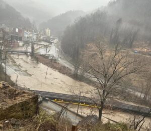
Peck said this heavy rainfall caused most of the southern West Virginia rivers, such as the Tug Fork, Coal, and Guyandotte rivers to reach the flood stage.
“Certainly most across the south came up very quickly and then receded very quickly,” Peck said. “Here in the Metro Valley, still looking at the Coal River coming up to moderate flood at Tornado, the Coal is currently in moderate flood down a little bit further south.”
He said main stem rivers like the Kanawha River in the Metro area were not expected to reach flooding levels, but it was expected to rise another couple of feet before starting to recede.
According to Live Storm Chasers, a major flooding stage of 21.79 feet was reported along the Tug Fork River in Welch in McDowell County from Saturday night and early Sunday morning’s rainfall, approaching a record set back in 2002 at 22.1 feet.
National Weather Service Meteorologist Levi Cornett had previously stated that water from Elkhorn Creek was into homes and businesses in Welch. At a little after 8 p.m. Saturday a weather station measured more than 3.4 inches of rain had fallen in Welch alone.
Governor Patrick Morrisey issued a state of emergency in 10 counties at around 10:30 p.m. Saturday including Cabell, Greenbrier, Kanawha, Logan, Mercer, McDowell, Mingo, Raleigh, Summers and Wyoming counties.
A state of emergency was declared in Mercer County Saturday evening with high water reported and some roads blocked, and a state of emergency in McDowell was declared for earlier that day. Summers and Boone counties also reported high water.
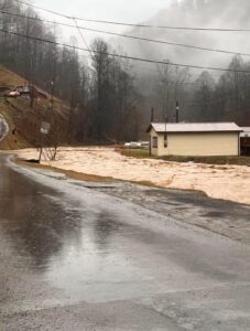
There were also a number of water rescues occurring in Wyoming County, particularly in the town of Oceana.
Kanawha County Emergency Manager C.W. Sigman said Kanawha County was not as nearly as impacted by this storm as those to the south were.
He said they had only received a couple of calls pertaining to water rescues that were not serious and were resolved without anybody having to get rescued.
Sigman did add though that Kanawha County was certainly not free from the affects the heavy rain produced as they were still watching the tributaries with caution around noon on Sunday.
“We did have a lot of culverts overflowing and a lot of water going across the highways, and right now our biggest concern is the Coal River is going into flood right now and several of the roads are closed,” he said.
He said the Coal River was expected to get up to 28 feet, and Coal River Road above Tornado was already covered with water as well as Farrell Road and Strawberry Road in that area.
Flooding on the Big Coal River in Boone County was reportedly cutting off access to homes.
Peck said they are now bracing for dropping temperatures by Sunday afternoon.
“We have a strong cold front coming through a little bit later this morning into this afternoon, that’s going to drop the temperatures from the 50s back down to the 30s this evening and then tomorrow morning they will be back down into the teens,” he said.
He said in addition, that cold front will bring about some snow as well and create icy road conditions.
“With all of this rainfall, especially on these secondary routes, any kind of snow abatement that was put on there will be washed off, so potentially some slippery conditions for tomorrow morning,” Peck said.
Sigman said the tributaries will recede, but the snow and cold weather will create more challenges to come in doing any type of flooding assessment and clean up.
“The Coal is going to come up but it will drop out pretty quick, and then it will be just cold and nasty during the clean up, and that water coming across the road right now will freeze up tonight when it gets really cold and we’ll have some slick spots,” Sigman said.