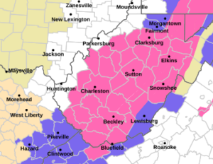
Winter Storm Warning
URGENT - WINTER WEATHER MESSAGE
National Weather Service Charleston WV
324 PM EST Sat Feb 21 2026

WVZ027-028-030-032-039-040-515>523-525-526-220430-
/O.CON.KRLX.WS.W.0004.260222T0600Z-260224T0600Z/
Clay-Braxton-Lewis-Taylor-Upshur-Barbour-Northwest Raleigh-
Southeast Raleigh-Northwest Fayette-Southeast Fayette-Northwest
Nicholas-Southeast Nicholas-Northwest Webster-Southeast Webster-
Northwest Pocahontas-Northwest Randolph-Southeast Randolph-
Including the cities of Gassaway, Prosperity, Craigsville, Holly
River State Park, Weston, Meadow Bridge, Cowen, Sutton, Webster
Springs, Elkins, Summersville, Oak Hill, Buckhannon, Beckley,
Grafton, Birch River, Richwood, Clay, Snowshoe, Montgomery,
Burnsville, Fayetteville, Sophia, Belington, Harman, Philippi,
and Bradley
324 PM EST Sat Feb 21 2026

...WINTER STORM WARNING REMAINS IN EFFECT FROM 1 AM SUNDAY TO 1 AM
EST TUESDAY...

* WHAT...Heavy snow expected. Total snow accumulations between 5 and
  12 inches. Winds gusting as high as 45 mph.

* WHERE...Portions of central, northeast, northern, and southeast
  West Virginia.

* WHEN...From 1 AM Sunday to 1 AM EST Tuesday.

* IMPACTS...Roads, and especially bridges and overpasses, will
  likely become slick and hazardous. Whiteout conditions are
  expected and will make travel treacherous and potentially
  life-threatening. Travel could be very difficult to impossible.
  The hazardous conditions could impact the Monday morning and
  evening commutes. Gusty winds could bring down tree branches