

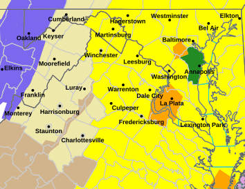
MARTINSBURG, W.Va. — The National Weather Service in Baltimore/Washington has West Virginia’s eastern panhandle under a tornado watch until 7 p.m. Monday with a strong storm system moving through the area.
The watch covers Jefferson, Morgan and Berkeley counties.
Tornado warnings were posted earlier in the day in parts of Maryland and nearby Loudon County, Virginia.
“Really anytime after noon is going to be the serious time. You do not want to be out driving when that squall line comes through,” said Will Astle of Eastern Panhandle Weather in an interview with WEPM Radio.
The rest of the state has experienced strong winds and rain with snow on the way.
Those who had become accustomed to the warm temperatures from last week will be sorely disappointed in the early part of this week in West Virginia. Forecasters said Monday’s thunderstorms will turn into a cold front drawing air from the Great Lakes into West Virginia.
Temperatures will plunge throughout the afternoon and eventually rainfall will become snow.
“Tonight into tomorrow morning and even Wednesday morning we’ll have possible slick spots from the rain freezing to black ice,” said James Zvlensky, meteorologist with the National Weather Service in Charleston.
Lowland counties in western West Virginia can expect a coating to an inch of accumulation. Higher elevations will see 2 to 4 inches of snow.
All across West Virginia temperatures will dip below freezing and deliver a killer freeze to tender plant or flowers. It’s advised you cover any young plants for the night to protect them from the cold air.