


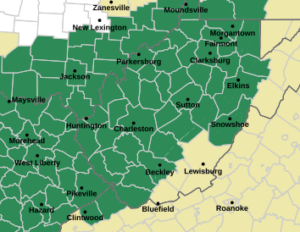
CHARLESTON, W.Va. — The National Weather Service has placed most of the state under a flood watch through Sunday morning.
Heavy moisture is expected to move in from the south with a weak flow system that will cause the storms to be slow-moving, according to National Weather Service Meteorologist Levi Cornett.
“It’s very rich moisture and we also have very weak flow,” Cornett said. “So most of this stuff that comes through and pops up in the afternoon just kind of sits up over the area and dumps a bunch of rain.”
The counties under the watch include all counties with the exception of Mercer, Monroe, Summers, Greenbrier, Brooke, Hancock, the Potomac Highlands and Eastern Panhandle counties.
Cornett said it’s tough to predict where the heaviest rain will occur. He said areas that have had heavy rain in recent weeks including parts of the southern coalfields and central West Virginia counties would be at higher risk.
Gov. Patrick Morrisey has parts of Boone, Logan and Raleigh counties under a state of emergency after flash flooding that took place two weeks ago. Another storm system in recent weeks produced high water in an area stretching from Roane County east into Upshur County.
Cornett said the storms begin Thursday but the heaviest rain is expected after that.
“From Friday mid-morning through the afternoon and then again on Saturday we’ll have a chance for flash flooding,” he said. “It’s going to be kind of what we’ve been seeing, some areas will see morning shower activity and then by afternoon it will be a mix of showers and thunderstorms in there too.”
Cornett said high temperatures will be in the 80s.