

(Video courtesy: Ian McKee)
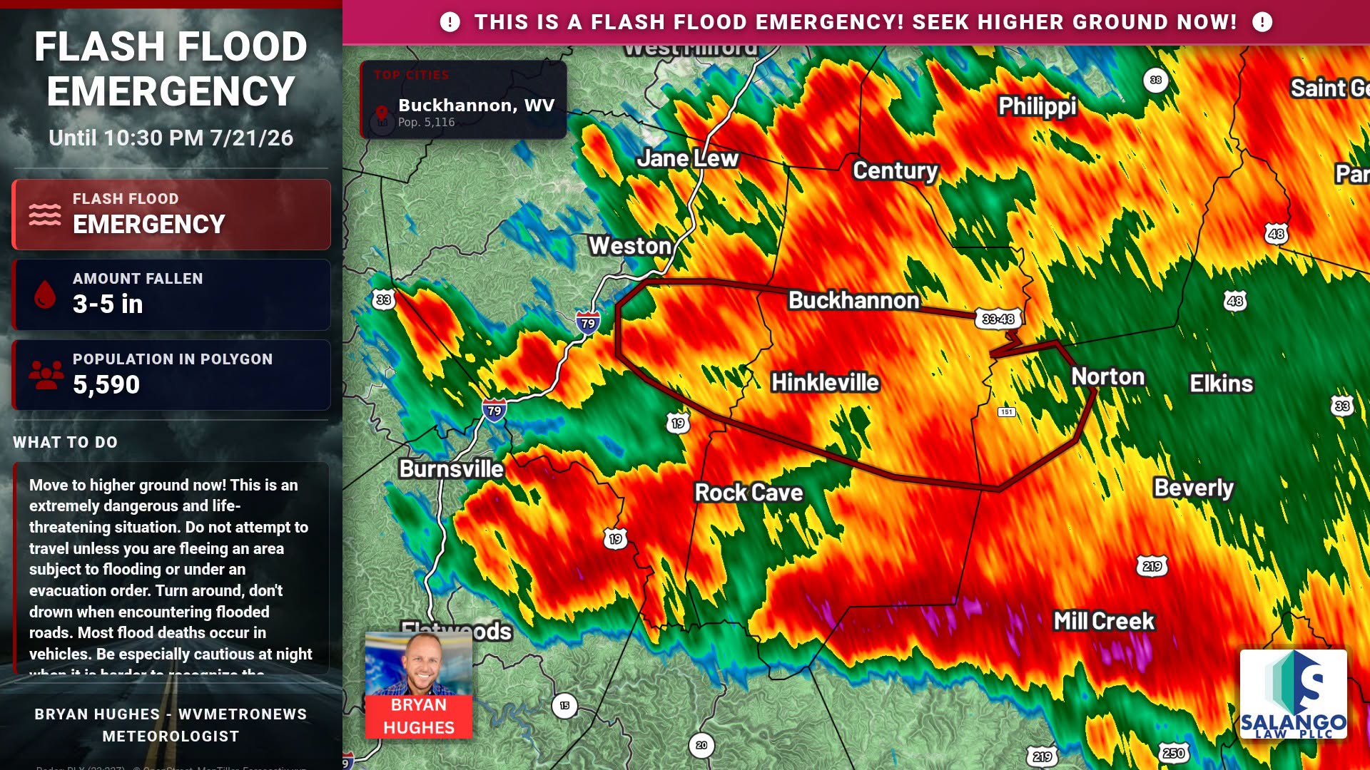
CHARLESTON, W.Va. — The National Weather Service in Charleston has elevated the ongoing disaster in central Upshur County to a Flash Flood Emergency, officially declaring the catastrophe a “Particularly Dangerous Situation” as severe storms continue to batter the state.
Emergency officials are urgently pleading with residents in and around Buckhannon, Tallmansville, Overhill, French Creek, Ellamore, and Horner to seek higher ground immediately. The warning remains in effect until 10:30 p.m. EDT.
According to the National Weather Service, Doppler radar indicated that between 3 and 5 inches of rain had already fallen across the warned area by 7:26 p.m., with an additional half inch to an inch still possible. The extreme deluge has triggered life-threatening flash flooding of low water crossings, creeks, urban areas, highways, and underpasses.
Several swift water rescues are actively underway, alongside reports of significant structural flooding. The relentless floodwaters have severely compromised infrastructure, including U.S. Route 33, which is experiencing life-threatening inundations between mile markers 2 and 5, as well as between mile markers 15 and 17. “Move to higher ground now! This is an extremely dangerous and life-threatening situation,” the National Weather Service stated. “Do not attempt to travel unless you are fleeing an area subject to flooding or under an evacuation order.”
Safety officials reiterate that most flood deaths occur in vehicles and strongly urge motorists to “turn around, don’t drown” if they encounter flooded roads. Navigating the region is exceptionally treacherous tonight, as darkness makes it exceedingly difficult to recognize the depth and speed of floodwaters.
Regional Impacts Continue to Mount
-
Marion & Taylor Counties: First responders remain impacted by high water, with emergency dispatch earlier dealing with overwhelming call volumes and open 911 lines. Fire departments in Taylor County have been managing a surge of calls, including a response to a fallen tree on a vehicle in Flemington.
-
Kanawha Valley & Western WV: The National Weather Service continues to monitor severe thunderstorm threats across Cabell, Kanawha, Lincoln, and Putnam counties, warning of heavy rain, 60 mph wind gusts, and hail capable of causing further damage.
-
Ritchie County: Travel conditions remain severely deteriorated, with the roadway near the Central station off Route 50 reported as impassable earlier in the evening.
-
Boyd County, KY: Just across the border, flash flooding completely blocked the southbound lanes of the 3200 block of US 23 in Catlettsburg, where vehicles became stranded in the high water.
From Meadow Street in Buckhannon. Courtesy Joe Kinzer pic.twitter.com/e2ZeVoQV6m
— Jeff Jenkins (@JeffJenkinsMN) July 22, 2026
Emergency management agencies across the state are operating at maximum capacity, with mutual aid being requested across county lines to support the most devastated areas.

Officials urge all residents in the affected Flash Flood Emergency zone to move to higher ground immediately and strictly avoid driving into flooded areas.
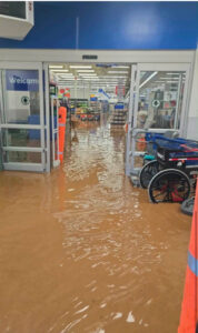
The Walmart store and its parking lot in Weston were flooded, with water sweeping through the area.
State Senator Robbie Morris, R-Randolph, told MetroNews that Barbour County is getting impacted again by heavy rainfall. The county is already under a State of Emergency after flash flooding Saturday night.
“Those same areas are getting hit again, in addition to new areas,” Morris said. “So, Barbour County is struggling right now, in addition to Upshur and others. (It’s) not a good situation.”
“Upshur County has been hit really hard,” Morris added. “Buckhannon is flooding significantly. Still waiting on reports from others, I’ve seen where Corridor H between Weston and Buckhannon is flooded and impassable in parts.”
Morris said he’s reached out to Gov. Morrisey’s office to see what the plan of attack is once the rain subsides. He said Buckhannon has issued a shelter-in-place order. He urged everyone to stay safe.
“Heed all the warnings, do not cross moving water over roadways, move to higher ground if you can, don’t risk anything,” Morris said. “If you have an emergency, try and contact 911.”

In the northern part of the state, Marshall County OES Director Tom Hart said they received lots of rain quickly.
“We’ve received anywhere from 2.75 to around 4 inches of rain in various parts of the county,” Hart said. “The hardest-hit area so far has been the Little Grave Creek area in the Glendale area.”
“Glendale Fire Department had to do a water rescue, someone that had driven into the flood water,” Hart added. “They were able to rescue them safely.”
The weather service has most counties under a severe thunderstorm watch until 8 p.m. Tuesday and nearly the entire state under a flood watch until early tomorrow morning.
Gov. Patrick Morrisey put all 55 counties under a State of Preparedness earlier Tuesday including:
–Activating the State Emergency Operations Plan to coordinate statewide resources and response strategies.
–Ordering key personnel and emergency assets to prepare for swift mobilization as conditions evolve.
–Delegating administrative authority to the Director of the West Virginia Emergency Management Division (WVEMD) to ensure the seamless delivery of essential emergency services.
Appalachian Power and Mon Power reported a few thousand customers without service Tuesday evening.