


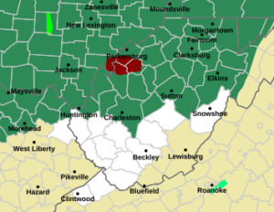
CHARLESTON, W.Va. — The National Weather Service has issued a flood watch for most of the state beginning late Tuesday into through Wednesday night.
National Weather Service Meteorologist Joe Curtis said Tuesday’s mainly light rain will get heavier Wednesday.
“It’s been raining for so long the ground is saturated and areas that have recently seen two or three inches, if they get another round of really heavy rain they may see a greater potential of flooding,” Curtis told MetroNews Tuesday afternoon.
Curtis said there could be some thunderstorms with the weather front that moves through Wednesday but the potential for flooding is of greater concern.
“Those little pinpoint areas where heavy thunderstorms moved through may be at a higher risk but overall, general, all of us have some risk (for flooding),” Curtis said.
The counties under the flood watch Wednesday include:
Cabell, Mason, Jackson, Wood, Pleasants, Tyler, Putnam, Kanawha, Roane, Wirt, Calhoun, Ritchie, Doddridge, Clay, Braxton, Gilmer, Lewis, Harrison, Taylor, Upshur, Barbour, Webster, Randolph, Ohio, Marshall, Wetzel, Marion, Monongalia, Preston and Tucker counties.
The National Weather Service did have a flash flood warning out Tuesday afternoon for parts of Wood, Jackson and Wirt counties.