

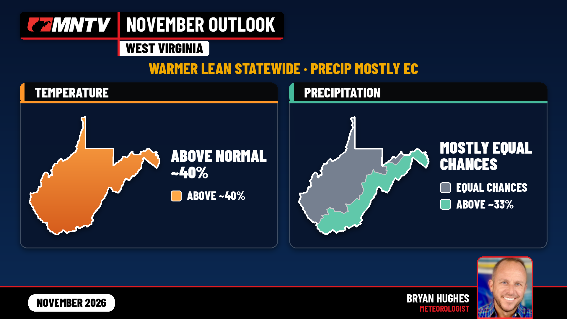
Halloween candy is still on the shelves, leaves are hanging on in a lot of spots, and folks are already asking what November will feel like. Fair question. Here’s the short version from NOAA’s Climate Prediction Center: November leans milder than normal across all of West Virginia. On how much rain or melted snow we actually get, most of the state is a toss-up. Only the Eastern Panhandle and parts of the southern and southeastern counties pick up a slight lean wetter on totals.
That outlook was issued October 15. CPC refreshes the November monthly maps on Saturday, October 31 — the day after this package — so we’ll watch that update closely. Until then, these are the official odds we’re working from.
Temperatures: a statewide warmer lean
CPC puts all of West Virginia in the above-normal temperature camp for November — about a 40% chance of finishing warmer than the 1991–2020 normal. That includes Charleston and the Kanawha Valley, the Ohio Valley lowlands, north-central West Virginia, both panhandles, the southern coalfields, and the Allegheny Highlands. There’s no north-south or mountain-valley split on the official map. One statewide lean.
For context, Charleston’s Yeager Airport has a November mean of about 46°F (average high near 57°F, low near 36°F). CPC is tilting the odds toward finishing above that mean — not calling a specific departure, and not promising every day will feel mild. November still swings storm to storm. A colder shot can still show up. The monthly signal is just saying the milder side of the ledger is favored.
Confidence is modest, and CPC itself treats November as a transition month. The warmer lean is real. It is not a lock.
Precipitation totals: mostly equal chances
Here’s where a lot of people get tripped up. CPC’s precipitation outlook is about how much liquid-equivalent precip falls over the month — rain plus melted snow — compared with normal. It is not a snowfall forecast, and it is not a rain-versus-snow call.
For most of West Virginia, including Charleston, Huntington, Parkersburg, the Kanawha and Ohio valleys, north-central counties, and nearly all of the Northern Panhandle, CPC has equal chances. That means roughly a one-in-three shot of above, near, or below normal totals. No official lean wetter or drier on monthly amounts for the MetroNews core.
A slight lean toward above-normal precip totals does clip two corners of the state, at the weakest CPC “above” contour — about 33%:
- The Eastern Panhandle (Berkeley, Hampshire, Hardy, Jefferson, Morgan; Mineral is closer to equal chances)
- Parts of the southern and southeastern counties — the Beckley–Bluefield–Princeton side of the coalfields, plus the southeastern mountains (think Greenbrier, Pocahontas, Pendleton, Grant, Randolph)
Farther west in the coalfields and around Elkins and the northwestern highlands, totals stay in equal chances. Plain English: do not sell a statewide “wet November” on totals. Most of us are sitting in the middle of the deck.
Rain vs. snow: a local read, not a CPC map
CPC does not issue a November snow outlook. What I can say, clearly labeled as a local read tied to the warmer lean and a strengthening El Niño, is this:
When systems move through the lowlands — Charleston, Huntington, Parkersburg, and the rest of the Ohio and Kanawha valleys — a larger share of that precip is more likely to fall as rain than as snow. More liquid, less frozen. That can be true even where monthly totals are equal chances.
The high country is still colder. Mix or snow is still on the table for individual events in the mountains. The monthly temperature lean just favors fewer deep freezes than a classic cold November. And do not equate that slight wetter lean on totals in the Eastern Panhandle and southeastern mountains with “more snow.” Totals and snow type are different questions.
What’s driving it
El Niño is the main driver. CPC has an El Niño Advisory in effect, with a strong-to-very strong event favored into winter. The pattern tends to push the storm track farther south — more Gulf and Southeast into Mid-Atlantic systems, and less locked-in Arctic cold for the Ohio Valley.
November is still a transition month. Model spread on how far north the wet signal reaches is exactly where West Virginia sits for precip — which is why most of the state lands in equal chances on totals.
Bottom line for November
- Milder odds statewide — about a 40% chance of above-normal temperatures everywhere in West Virginia.
- Rainfall totals mostly up in the air for Charleston, the Ohio Valley, north-central WV, and most of the Northern Panhandle. A slight wetter lean on totals only in the Eastern Panhandle and parts of the SE coalfields and mountains.
- Early-season snow less favored in the valleys than in a cold November; mountains can still see mix or snow on individual days.
- CPC updates these November maps on Saturday, October 31. We’ll refresh if that update shifts the picture for West Virginia.
Questions for your county? Drop them in the comments.
Sources: NOAA Climate Prediction Center Monthly Temperature and Precipitation Outlooks for November 2026, issued October 15, 2026; CPC 30-day outlook discussion; NCEI 1991–2020 normals (Charleston Yeager).